Mud Mill Pond Fishing Spot
- Mean Depth: 4'
- Max Depth: 7'
- Last Modified By: vinny60 on 09/22/09 10:55 AM
- Ask about Mud Mill Pond in our Fishing Forums
Photos
Fish Species
Comments
-
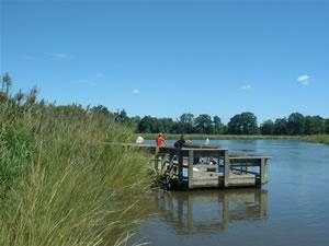
Although much of the pond shoreline was vegetated with water willow, smartweed, and other emergent plants, there was little vegetation in the pond itself. Spatterdock occurred in scattered patches throughout the pond and crappie appeared to hold in the cooler water of those beds. Duckweed was present among the shoreline plants but did not affect angling.
Mud Mill Pond Baits and Tackle
Stick Bait Check Prices
- rapala suspending husky jerk
Bass Jig Check Prices
- green pumpkin rattle jig
Mud Mill Pond Description
This pond was undoubtedly named for the muddy brown color of the water. As might be expected, largemouth bass and other members of the sunfish family present in below average numbers in comparison to other Delaware ponds. Although the amount of silt in the water likely affects the spawning success of these nest-builders, reproduction has been successful enough to produce low moderate numbers of bass with an occasional citation. Bluegill and black crappie were also present in low to moderate numbers. However, nice size crappie were occasionally taken, either in the area near the dam or around the island. Pumpkinseed sunfish were also present.SPECIAL CONDITIONS The shallow depth throughout much of the pond makes running an outboard difficult at times. Visibility is generally poor due to the muddy water so maintaining a legal no-wake speed is best to avoid damage to outboards. This pond lies on the state line between Maryland and Delaware. Since there is no reciprocity agreement between the two states, anglers must be sure they are holding an appropriate license for their location on the pond.